Introduction
The system of the Monsoon (derived from the Hindi word, “Mausam”) comes as a great relief after the hot Indian summer. An entire season dedicated to the rains, when the gods go off to sleep, in India makes for an entirely different concept from that in the West. Remember, “Rain, Rain, go away, little Jonny wants to play” well it’s quite the opposite of that in India!
In fact during the monsoon months it is finally not too hot to step out and one can enjoy the great outdoors. The appetite returns which had turned to liquids during the peak of summer. Of course the mosquitos come too, but then that’s a small price to pay for the many benefits. One knows that monsoon is around the corner, when the frogs start croaking away whilst they lay their eggs bringing alive the eerie silence of summer. The rain-bird of India or the Pied Cuckoo is spotted mysteriously with its distinct “Piu, Piu” calls just before it begins to rain. The migratory bird flies over the vast Indian Ocean from East Africa to make it in time for the beloved Monsoon of India. “Chatak”, as the bird was known in ancient India, has been used by many a poet as a metaphor of love and pining. A lazy, parasitic bird can fly across thousands of miles in time to greet the monsoon. That’s how attractive, romantic and enjoyable this season is.

Pied Cuckoo or Chatak as seen just before the rains in the Western Ghats.
A lesson in Geography – The Western Ghats
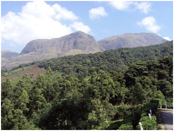
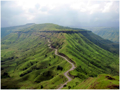
The monsoon is then the best time to explore what is known as the Sahyadris Range or the Northern part of the Western Ghats, a colossal wall formed millions of years ago due to volcanic eruptions (known as Deccan Traps) that slope downwards as it goes east and climbs higher as proceeds southwards towards the states of Karnataka and Kerala. The Western Ghats extends from north to south for about 1,700 kms encompassing three ranges as part of its range.

The Western Ghats as seen from space.
The Northern part of this range, from the Tapi River near Surat to the Terekhol creek in Goa, is called the Sahyadri. The Sahyadri range is 640 km long from north to south, and is 10 to 20 kms in width on east-west axis. The average elevation is 1,200 meters, the tallest peak being Kalsubai (1,646 m) near Igatpuri. The middle portion of the Western Ghats (Goa and Karnataka), called Attari, runs up to the Nilgiri hills (Ooty).
The continuous chain of the Western Ghats is broken at the Palghat Gap. Extending southwards from the Palghat Gap into Kerala the elevations rise, culminating in the Anaimudi(2,695 m), the highest peak of the Western Ghats. The Anaimudi is also the nodal point from which three ranges move in three different directions – the Annamalai in the North (North of Munnar), the Cardamom hills (South of Munnar) in the South and the Palani hills (Kodaikanal) in the east.
Anaimudi, the highest peak of the Western Ghats near Munnar.
A “Ghat” in common language means a pass and hence the colloquial and rather derogatory term for a local here in Maharashtra coined by “outsiders” is “Ghati” or “the one who lives in the Ghats”. To reach from the Konkan (flat, coastal land that exists between the Western Ghats and the Arabian Sea, which is known as “Kanara” in Karnataka and “Malabar” in Kerala) to the Deccan Plateau, an eastwardly sloping plateau consisting of “Maval” (forested area with lava rocks at its base, forms the approach to all hills in the Ghats) and “Desh” (vast plateau where most of the towns and cities are located), or vice-versa, one must pass through a Ghat or a pass. Many of these ghats are now motorable roads. It was the complex topography of this land that the medieval ruler Shivaji Maharaj used to his advantage. The British were simply were not able to capture him in spite of their most devious plans and he died from dysentery out of all things!! No wonder his enemies called him the “mountain rat”.
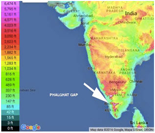
A contour map of the Western Ghats and Deccan Plateau showing the Phalghat Gap through which ancient migration of humans from the current state of Tamil Nadu to the State of Kerala might have occurred.
A lesson in Geography (condt.) – The River Systems
All the major river systems that start in the Western Ghats flow eastward except for the Narmada and the Tapi. The sources of all the three major river systems that originate in Maharashtra are temples (the major agricultural advantage of these rivers is taken by the southern states where their deltas lie). The ancients knew what better way to preserve these sites, make them into places of worship!!

Map of India showing the three rivers, Godavari, Bhima and Krishna which all originate in Maharashtra.
The Godavari’s source is at Trimbakeshwar near Nasik, which is one of the four places where the Khumbh Mela takes place and also one of the 12 Jyotirlings (most holy temples where Lord Shiva is worshipped). The Bhima River, which is also referred to as the Chandrabhaga because it flows as crescent moon shape near the holy town of Pandarpur (the Kashi of Maharastra) has its source at Bhimashankar near Karjat. The Indrayani River, which is a tributary of the Bhima River passes through the holy towns of Alandi etc. which are associated with medieval Maharastrian saints like Tukaram and Sant Gyaneshwar. Eventually the Bhima river joins into the Krishna though as a tributary it is longer than the Krishna river till that point. Lastly, the Krishna River has its source at Mahabhaleshwar, originally an ancient temple town and now a tourist hill station that houses both Shiva and Krishna temples.
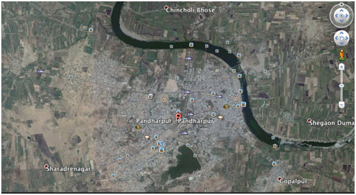
Bhima or Chandrabhaga river taking the shape of a crescent moon at Pandarpur (source: Google Earth).
A mythological perspective – Western Ghats
This coastal belt is spotted with temples dedicated to Parshuram, the hot-tempered Brahmin who in Puranic stories of ancient India rid the world of the warrior tribes 21 times over. He is one of the seven immortals in Hindu stories that live in all the four yugas (eons) and are still supposed to be alive in hiding in this age of darkness that we live in, The Kali Yuga.
He threatened the sea to retreat standing high on a summit of the Western Ghats with his many divine weapons he had won in boons from gods along with a his most identifiable weapon, The Axe. Parshu (means axe in Sankskrit) + Ram (incarnation of Vishnu, the preserver) = Parshuram. Fearing his wrath, the still waters of the deep-sea trembled with fear and excitement causing large ripples. But instead of the ripples causing a tsunami, the waters humbly retreated. Here stood before them a pious though violent seer, who is revered as one of the greatest human beings ever born. Though dressed like a Brahmin or holy man, his poise was that of a warrior. The entire Konkan belt emerged like a reverse implosion from the seabed. Now doesn’t this make a more interesting geography lesson?

Parshuram standing along with the Saraswat Brahmin Community (supposedly they came from the Saraswati River Civilization in North India) demanding the Sea-God to retreat.
Now that we have understood the bird’s-eye view geography, culture, mythology and brief history of the area we are ready to proceed into the recommended hikes treks and outdoor activities in the region known as Karjat, the valley just before the start of the Northern Sahyadris, only a 1.5 hours drive from Mumbai City and similarly from Pune.
Tooth Mountain Farms, Chowk Phata, Karjat
Tooth Mountain farms (TMF) and nursery is a privately run 20-acre estate right next to the famous ND Studio, named after the illustrious art director, Nitin Desai. Mr. Desai got his first big break with the film, “1942: A Love Story” in the year 1994 by director now turned producer, Vidhu Vinod Chopra. Post that there was no looking back for the talented son-of-the-soil of Maharashtra who has produced mega-television shows as well as art directed many period movies like Jodha-Akbar and Lagaan. Many big budget Bollywood movies, reality shows such as Big Boss and mega television series have been shot at the ND Studio.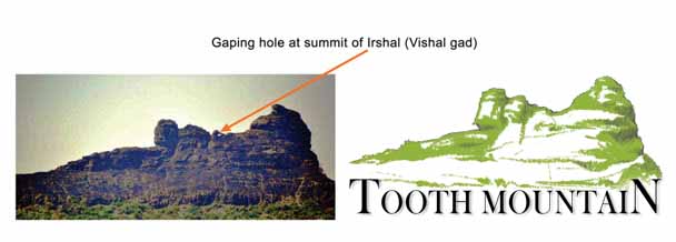
The Tooth Mountain Logo has been derived from the summit of Irshal (Vishal Gad). The hole on top can be seen from very far away.
TMF is a boutique farm-stay spread over lavishly landscaped lawns. It has four themed rooms each named after a flowering tree that grows at the estate namely Palash (Flame-of-the-forest), Parijat (Night-flowering Jasmine), Amaltas (Golden Shower tree) and Ashmantak (Variegated-Bahunia). The filtered lap-pool is under a gigantic Jamun Tree and is the highlight of the property. There is also a private man-made lake, a plant nursery and art village made entirely from earth on the premises. This will serve as the base camp for all excursions around the Karjat area, and I will mark distances from TMF to various attractions that I am about to reveal to you here in this blog post. Also keep referring to the comprehensive map, which has been exclusively made for this blog post showing the topography, ghats and contours of this area.
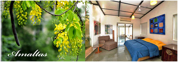
A sample suite room named after a flowering tree that grows on the property
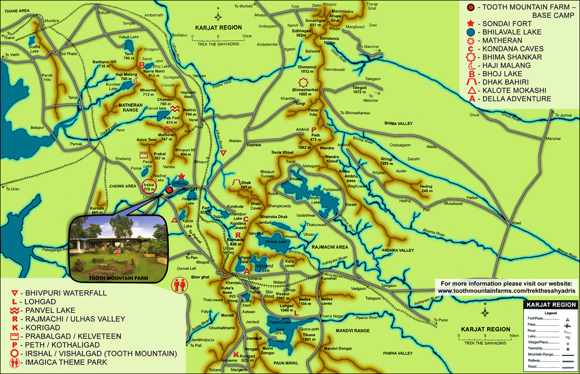
Please save this map on your desktop and you can zoom in for details. All the recommended trips and treks from Tooth Mountain Farms are mentioned on the map.
Leisurely Day trips – Picnic spots, Waterfalls, Forts, Caves and Lakes (all distances are marked from TMF)
Bhilavle Lake – 2.6 kms

Bhilavle Dam near Tooth Mountain Farms & Nursery
One can walk to this beautiful dam, which is a short walking distance from TMF on the road going towards Karjat. There is a small mud road, which leads to this artificial lake. It is about 1 km from the main road. A small dam and a few trees around form the right setting for spending an enjoyable day.
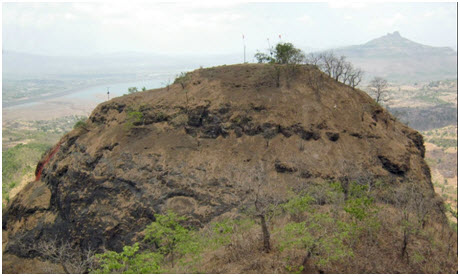
Sondai Fort – 8.8 kms
Sondai Fort in the monsoon season
Sondai is not a popular fort. It is a small trek from TMF and offers a beautiful view of Morbe Dam, Prabalgad, Irshalgad, Rajmachi, Songiri forts and Matheran mountain range. This was used as watchtower during the rule of Marathas. The base-village of Sondewadi. The route is easy and it takes approx 1.5 hrs to reach the top.
In monsoon, a couple of rocks on the way become slippery. There are two water cisterns on Machi (at the base of the pinnacle) and steps are carved out of rocks to go on the topmost point where an idol of Sondai Devi stands. Wavarle is another village from where a bit difficult approach to the fort passes through the dense forest. Overall it’s an ideal one-day hike in monsoon for new comers in the trekking field.
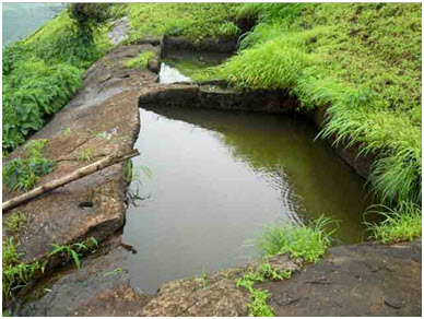
Pond on summit of Sondai Fort.
Sondai fort with Irshal or Tooth Mountain seen in the backdrop.
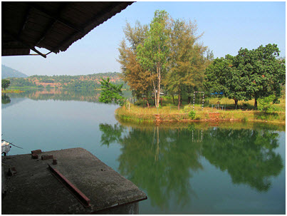
Kalote/Mokashi – 8.7 kms

Kalote Lake at the Village of Mokashi at a short distance from Tooth Mountain Farms.
Take the NH-4 (old Mumbai-Pune Road) towards Khopoli. About 7 kms down the road from TMF one has to take the small left road, which is almost unnoticeable. This is a small lake flanked by hills on three sides and is a good camping site. The lower col behind the central village leads to Palasdari (lake) while the Northern ridge, if crossed, descends to Bhilavle (dam). There is also a beautiful waterfall in monsoon season about a 1 km trek from the lake.
A view from the resort at Kalote Lake.

The Sun’s reflection on Kalote Lake.
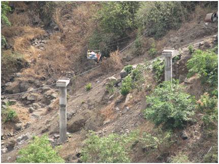
Bhivpuri Waterfalls – 14 kms

Rappelling alongside the waterfall at Bhivpuri road.
Drive towards Karjat, and turn left to go towards Nerul/Matheran Road. About 7 kms down this road, one will see Bhivpuri Hill on the left and on the right one can see the next train stop, Bhivpuri. Park your car at a safe spot near the station and from there one can cross over to the East side. It is about a 1 km walk from the railway station, situated on the Ulhas River. Don’t miss out on the rappelling experience here.
Kondana Caves – 20 kms

Kondane Caves Sign post.
There are the caves at the base of Rajmachi Fort. They are a group of 16 Buddhist caves more than 2,000 years old are situated in the forest and not much frequented. They are a little above the banks of the river Ulhas. Drive to Kondivide village. A cart track leads to the caves (3km). Alternatively one can descend to the caves from Rajmachi (see map).

Waterfalls at Kondane Caves, Karjat.
Panvel Lake – 32 kms (by road from TMF)
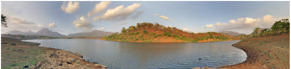
Panaromic view of the Panvel Lake.
This is a small artificial lake in a blow at the base of Chanderi and Matheran (see map). It has many approaches and provides excellent opportunities for cross-country walks in the rain. From Vangani station proceed to village Vaghachiwadi (3km) and over the saddle of Chanderi-Nakhind to village dawla (6km) on the other side (West). The lake is nearby. Other approaches are: (a) over the saddle of Nakhind-Peb fort from Neral (10km), (b) Descent from Porcupine Point of Matheran (3km), (c) Traverse at the base of Matheran from TMF to the lake (13km) (d) The motor road from Panvel to village Nere (26kms) and a 6 km walk to the lake.
Bhoj Lake – 41 kms

Tourists enjoy themselves by Kondeshwar/Bhoj Lake
This is an artificial lake in enhancing surroundings at the base of Navra-Navri (see map). From Badlapur Station, on the east, a bus road leads to village Javli (3km). About 2 kilometers ahead is the dam and the lake (via village Dahvili). The Navra-Navri ridge can also be climbed or traversed. Near the northern shores of the lake (right), there is a temple of Kondeshwar. It is under a huge overhang and worth a visit.

An old Shiva temple alongside the river at Kondeshwar.
Short Day Treks – back to TMF same day
Irshal/Vishalgad (Tooth Mountain Farms) – 6.3 Kms

Many years ago, a group of school and college friends had trekked to Irshal (Vishalgad). We are sitting in the hole that can be seen from far at the top of the mountain.
One can simply start walking to the base from TMF or then take the road to the base of this mountain, which is a few kilometers from TMF. A 3 km uphill track leads to Vishalwadi at the foot of the final climb. From the village, the route lies over the extreme left ridge in the northerly direction and then from behind the hill to a small gap above the hole. Water is available here. Straight ahead is a 10 m rock climb to the loose scree above. A very exposed scree traverse from the left leads to the small grassy top. One should be very careful on descent, as any slip would be difficult to check. A connecting ridge makes an enjoyable traverse from Vishalwadi to Prabal.
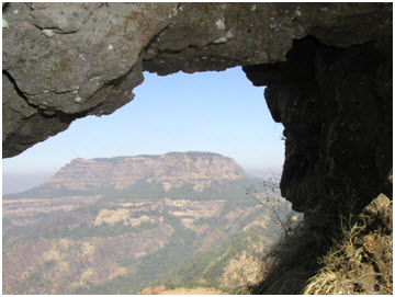
View of Matheran from the hole of Irshal. Wind passing through this hole makes a constant whistling sound.
Rajmachi/Ulhas Valley – 20 kms
The semi-circular valley enclosed between Rajmachi massif on one side and the Karjat-Khandala rail-track on the other, is the main catchment area for the river Ulhas. During the monsoons or just after, it presents a grand sight with numerous waterfalls and greenery. One can spend a quiet day on the banks of the Ulhas (Ulhas nagar gets it name from this river that starts here and ends at Ulhas Nagar) or complete a long trek along it. There are numerous possibilities. Descend from Rajmachi and walk along the Ulhas, or get alight at the Thakurwadi railway halt, on the ghat line, descend to the banks of the Ulhas and walk up the river to Khandala. Kondana Caves and Bhairoba Dhak are some of the places one can visit in the Ulhas Valley. In the monsoon, The Ulhas river is difficult to ford, so one must be careful to start on the correct side of the river for a trek.

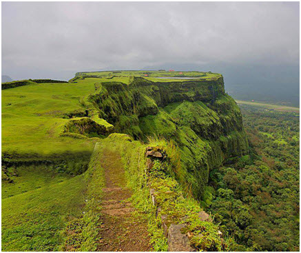
Spectacular views from the Rajmachi Fort.
One of the prominent hill forts guarding the Bhor Ghat, is the isolated twin peaked fort of Rajmachi. It is about 10 km as the crow flies from Khandala and about 20 km by trek. The fort is separated from the main mass of ghats and is joined to them by its northwest end. A tongue, about 275 m broad, with endless curves, joins the fort to the Khandala plateau. During the long approach, the fort appears to be very near all the time. The higher peak is known as Shreevardhan and the lower one, as Manoranjan. They are joined by a common col which has a small temple on it. The village of Rajmachi is at the base of the lower fort.
From Lonavala, proceed to Tungarli and descend to the plateau further ahead in the north. Here the routue from Khandala joins it. A cart-track leads to village Udavne (13km). A little before reaching Valvand village (6km), turn of to the west (left) and go across a nala. One now enters the fort through its ruined walls. An easy walk leads to the col between the two peaks from either side. The higher peak has a cave and a grand view. Both the peaks are easy to climb.
From Rajmachi there are many trekking routes: (a) Kondana caves (b) Shirota Lake (c) Kondivde village.
Rajmachi forts had every known masters of its time. In 1648 Shivaji controlled it and later in 1713 Shau Maharaj of Kolhapur gave it to Kanhoji Angre. In 1730 it was with Peshwa Bajirao. Most interesting episode in history was in 1776 when Sadashiv Totya of Konkan, a small chieftan, captured it and started negotiations with Bajirao. As the negotiations prolonged Peshwa’s forces attacked and captured Rajmachi, and Totya ran away to Mumbai, to be arrested by Angre and was returned to Pune. He was executed by being crushed under an elephant. In 1818 the British Rajmachi easily.
Prabalgad/Kelve Teen – 20 kms
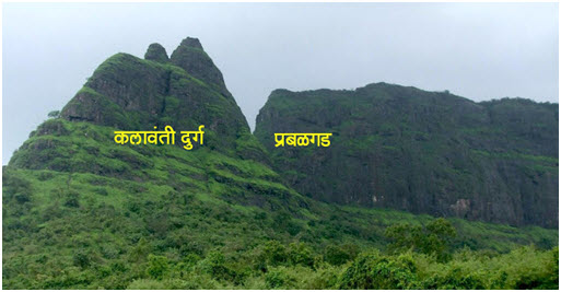
Prabalgad and Kalavanti Durg/Kelve Teen.
Prabal is a huge forested plateau, parallel to Mathran. In fact, Prabal was to be developed as a hill station, but there is a shortage of water. It can be seen from Matheran and all the nearby forts. Travelling on the main road from TMF to Panvel, get down at Poinje Village Phata, 6 km from TMF.
From the main higway, Poinje is 2 km. Climb up a small spur to the middle plateau. The Irshal-Prabal range runs northwest to southeast. From the plateau move north along the base of the wall. Climb up the southwest gully of Prabal on the right. This is the first gully on the traverse. The route takes one through a dilapidated fort wall. You will find a lake, a water tank (on the extreme southern end) and a huge, thickly forested plateau on the top.
Another route approaches Prabal from its norther end. From Panvel go towards Shedung, Belavli. Proceed to Vardoli (6km) and go up the fort by the same route.
From the middle plateau a connecting ridge leads to Irshal, or one can proceed across an old landslide, descend through the valley to village Varosa (6km) or climb to Matheran via the Shivaji ladder (10km).
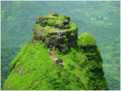
Kalavantin Durg, an ancient fort adjoining to the main mountain Prabal.
Kelve Teen/Kalavantin Durg – This is a prominent triangular pinnacle adjoining the northern edge of Prabal. Approach it from Panvel, Nere (9km), Vaje (4km) and turn off the Vajepur (2km) by road. This leads you to the base of the pinnacle. Climb up to the plateau to reach Machi village (2 km). The pinnacle is 1 km above with rocky steps leading up to it. Some drinking water in the tanks is also available. No direct approach to Prabal top is easily possible from here. Moving south along the plateau from Machi one can up Prabal by the traditional route.
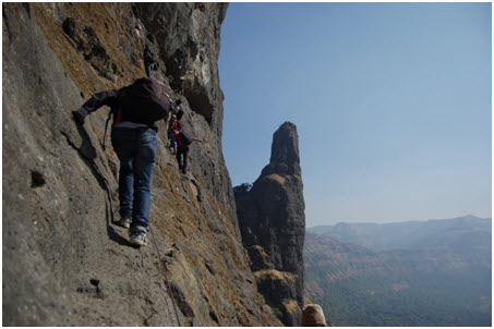
Dhak-Bahiri – 21 kms

A view of the summit.
Dhak Plateau is a huge flat-topped hill detached from the main range of the ghats. It has a long ridge falling towards Karjat. From Karjat take the road to Vadap (8km) via Dahili and Venagaon. A 5 km climb to the upper plateau among thick forest leads to village Dhak. Another 5 km of climb and one reaches the top of the plateau. Dhak is connected with Rajmachi and Kusur situated on the ghats.
Bhairi Cave is high up on a rock-face with a sharp pinnacle nearby. It is a unique place in the range. A giant cave of Bhairav is hewn out in a rock face. It has a water tank. It is an eerie place particularly due to the animal sacrifices still practiced here. On the Chaitra Purnima every year, a fair is held here.
From Karjat proceed to Sandshi via Khandpe. A complicated track leads to base of the cave (4km). A series of rock steps lead vertically up to the cave. The steps are blown off in certain sections near the cave making the approach and return difficult and exposed. Another longer route is to climb up the ghat to Jambuli village near the beautiful Kondeshwar temple. Traverse along the edge of the ghat between the Bhairi pinnacle and the ghats to descend to the base of the cave. Jambuli is served by a direct bus from Talegaon (near Pune) and is also approachable by a track from Valvand village near Rajmachi (see map).

A small rock summit excellent for rock climbing right next to the main peak.
Bhairi Pinnacle is a sharp pinnacle near the Bhairi cave. It offers a good climb of about 40 m. It has an easier approach from the east face, while other routes are more challenging. Another pinnacle 100 m higher up towards the ghat also provides a good challenge.
A steep climb for experienced trekkers.
Haji Malang – 47 kms to base.

A view of the HajiMalang Peak.
This is a prominent landmark in the vicinity of Kalyan, with the dargah of Baba Malang halfway up the mountain. One can take the car to the foot of the mountain from where a broad path leads to the dargah.
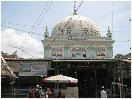
A view of the Dargah.
This path may be crowded and dirty, so one can climb up a ridge by alighting from the car a little before the broad path. You can also approach it by traversing from Talvi (see map). Above the dargah, there are many opportunities for rock climbing but only if one has proper gear.
Alternate mode of transport – try at your own risk!
Overnight Treks
Matheran – 15.9 Kms via trek.
This is a well-known hill station and a paradise for hikers, especially in the monsoon. It has many routes and one can always spend an enjoyable hiking day exploring these.
The main route is from Neral (11km) via shortcuts. The car now goes right up the plateau and one only needs to climb the last kilometer by foot or horses. Matheran, the plateau is an environmentally protected area and on the plateau no cars or motorbikes are allowed.

Monkeys are commonly found in Matheran.
Other routes are: (a) From Bhivpuri climb to the Garbat plateau (13km) to reach Garbat point. (b) from TMF via village Varosa go up the Shivaji Ladder (10km) to reach One Tree Hill point. (c) From vangani to Porcupine Point, Via Panvel Lake (19km), etc. Many such combinations are possible. A party can climb up from one route and descend from the other. There are many enjoyable walks through thick forests at the top. A separate route guide for Matheran is also separately available.

Beautiful sunset points, such as these are plentiful all over Matheran, are a great draw with the tourists.
P. Malet, who was Collector of Thane, discovered this hill in 1880. He noticed thick forest and enquired about the name of the hill from local villagers. In native dialect, they replied, “Mathe Ran Hai”, meaning, “Up there (Mathe) is a Jungle (Ran)”. Malet made regular excursions to it and finally a hill railway was constructed here in 1907. The toy train is also a great way to reach the top. The soil is red and on top excellent walking paths and a lake are charms of Matheran.
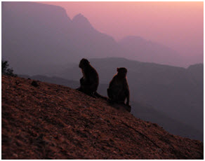
A pair of monkeys at a sunset point in Matheran.
Bhima Shankar – 37 kms to base for trek.
A scenic drive to Bhimashankar by road is also possible.
Bhimashankar is a famous pilgrimage site on top of the ghats. It is one of the Jyotirlings of Shiva and has a beautiful temple with a huge bell, a relic of the Portuguese times. Nag Phani, the highest point, is nearby and commands an excellent view. It is thickly forested and has many approaches. One can drive to the top now via a longer route from the Pune side. However, for hikers to enjoy the ruggedness, the best approaches are by climbing the steep and long route up the ghat.

The mighty Bhimashankar in the Monsoons.
From TMF drive towards Karjat, and then up to Khandas at the base via Kashele (14km). After a flat walk on 2 km, a track climbs up steeply along a small spur to the first plateau on which Padar Killa is situated. A long traverse on the north (left) takes one to village Koli (3 km).

Enroute a misty trek up the Bhimashankar Mountain.
Ahead, a rather steep and long climb leads to the thick forest above. Traverse north in the forest to reach the temple (6km). Another route, which is far steeper but shorter is to climb straight up to the upper plateau. A fascinating routue through rock-cliffs leads up to it. At two places wooden ladders help to overcome the cliffs. The route joins the original traverse route at Koli Village.
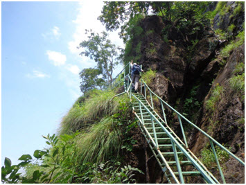
Ladders assist climbers to the summit.
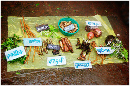
Exotic vegetables fresh from the forest enroute the trek.
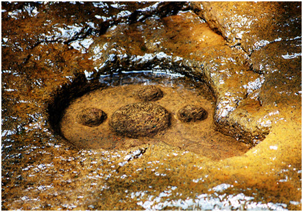
Gupt-Godavari the source of the Godavari River.

Bhimashankar the source of the holy Godavari River.
Lohgad – 40 kms

This hill fort, along with the neighboring Visapur fort is an important landmark. It is rather well preserved, with a series of five gates and high walls to stop any intruder. It has an excellent view and is delightful in the monsoons when it is covered in thick clouds. From Lonavala, proceed to the next railway station Malavli. Walk to Bhaja village (3km). The Bhaja caves are nearby. The track leading to Bhaja village from the station continues to climb up gently to the col between Lohagad and Visapur. Lohagadwadi is about 1 km ahead. A broad route leads to the top through strong fortifications. One can visit Visapur fort. On the return trek one can walk along the shores of Pawna Dam and come out via Shiv Khind to Lonavala.
This gentle fort of today played a large part in the history. Earlier it may be a Buddhist religious place but it is known that in 1564 it was here that Burhan Nizam Shah || was imprisoned. He bribed the commander of the fort, captured it and his next generation stayed here till 1578 and captured the throne of Ahmednagar from here. Then it changed hands, to Shivaji in 1648 and to Aurangzeb in 1665 and changed twice between these forces, in 1751 Damaji Gaikwad was imprisoned here and finally on 5th March 1818, Col. Deacon of the British Forces captured it easily.
Korigad – 52 kms
Once one of the most interesting places to hike from Lonavala, but now one of the easiest fort to climb as road has reached very near to its foot and steps have been cemented to its summit.
The fort lies in ruins covered with moss.
However the route to the base of this isolated fort is full of vegetation, flowers and variety of stones. The thick forest is recommended for camping in. A cross-country walk can be undertaken in winter, or in the full fury of the monsoons. From Lonavala, drive towards INS Shivaji to reach Ambavne. The motorable road winds up to the top of the ridge and continues via Ghushalgaon to reach Peth-Shahpur (14km) which is on the road. A good route leads to the top of the fort. The top is flat and much of it is occupied by four fairly big ponds, two of which are permanent. There are two caves and also a ruined temple.
It is said that when the fort was deserted in 1818, the temple ornaments were handed over to Mumbadevi, the goddess of Mumbai. A good view of Muslhi Lake can be had from here. In the monsoons, one may encounter fierce buffaloes on the top. They are allowed to live on the fort for many days, without being taken back to the village. Descending to Ambavne village on the other side, one can proceed to Mulshi Lake, or down the ghats to Telbaila or Sudhagad.
There is an old mortar gun on the top. When Col. Prother of the British forces advances against Koregad on 14th March 1818 this gun was loaded and ready to be fired against the British forces. But the charge from the gun blew up the magazine, ruined the gateway and burnt several houses in the fort itself. The fort surrended immediately.
Peth/Kothaligad – 35 kms

The funnel shaped mountain of Peth.
This is a small fort with a large cave at its base. It is detached from the main range. It has an interesting fortification at the top in the shape of a funnel with a rocky staircase carved in the middle. This funnel is known as Kotligad. From Karjat drive towards the village Ambivli via Kashele. A beautiful small lake near Ambivili is worth a visit. From Ambivli, you can climb to village Peth (3km) that is at the base of the fort. An easy climb on the top follows. The lower plateau is connected with Wandre Khind on the ghats in the east.
Excursions/Theme Parks/Adventure spots
Imagica Theme Park – 18 kms
This is a great one day or even two day attraction and very close to TMF. There are great rides, restaurants, playing areas, themed attractions.

A ride at Imagica Theme park.
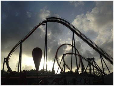
A rollercoaster ride at Imagica.

A themed area at the park.

Dancing fountains where kids can play.

A map of Imagica theme park.

Signages at the park.
Della Adventure – 30 kms
Della is India’s largest adventure park offering more than 70 activities. It is situated in Lonavala.
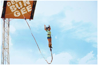
Bungee jumping at Della Adventure.

Go karting along mud tracks.

An experience to walk a dog for people who don’t have one at their home

Various rides at Della.

